Back مقاطعة أدير (آيوا) Arabic Adair County, Iowa BAR Адеър (окръг, Айова) Bulgarian আডায়ির কাউন্টি, আইৱা BPY Adair Gông (Iowa) CDO Адэр (гуо, Айова) CE Adair County (kondado sa Tinipong Bansa, Iowa) CEB Adair County (Iowa) Czech Adair County, Iowa Welsh Adair County, Iowa English
![Das Adair County Courthouse in Greenfield, seit 1981 im NRHP gelistet[1]](http://upload.wikimedia.org/wikipedia/commons/thumb/3/39/Adair_County_Courthouse_Greenfield_IA.jpg/298px-Adair_County_Courthouse_Greenfield_IA.jpg) Das Adair County Courthouse in Greenfield, seit 1981 im NRHP gelistet[1] | |
| Verwaltung | |
|---|---|
| US-Bundesstaat: | Iowa |
| Verwaltungssitz: | Greenfield |
| Adresse des Verwaltungssitzes: |
County Courthouse 400 Public Square Greenfield, IA 50849-1259 |
| Gründung: | 15. Januar 1851 |
| Gebildet aus: | Pottawattamie County |
| Vorwahl: | 001 641 |
| Demographie | |
| Einwohner: | 7.496 (Stand: 2020) |
| Bevölkerungsdichte: | 5,09 Einwohner/km2 |
| Geographie | |
| Fläche gesamt: | 1477 km² |
| Wasserfläche: | 3 km² |
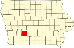
| Karte | |
 | |
| Website: www.adaircountyiowa.org | |
Das Adair County[2] ist ein County im US-amerikanischen Bundesstaat Iowa. Im Jahr 2020 hatte das County 7496[3] Einwohner und eine Bevölkerungsdichte von 5,1 Einwohnern pro Quadratkilometer. Der Verwaltungssitz (County Seat) ist Greenfield.[4]
- ↑ Auszug aus dem National Register of Historic Places - Nr. 81000224 Abgerufen am 17. September 2014
- ↑ Adair County. In: Geographic Names Information System. United States Geological Survey, United States Department of the Interior, abgerufen am 30. Januar 2011 (englisch).
- ↑ US Census Bureau: Search Results Total Population in Adair County, Iowa. Abgerufen am 4. Februar 2024 (amerikanisches Englisch).
- ↑ National Association of Counties Abgerufen am 17. September 2014
© MMXXIII Rich X Search. We shall prevail. All rights reserved. Rich X Search